 |
|
 A Date with Jordan
 |
|
| |
|

Holy land of Israel
and Jordan 12 days 11 nights |
desert castles or desert palaces
|
|
|
|
|
Stretching
east of Amman, the parched desert plain rolls on to Iraq and
Saudi Arabia. This is a place where endless sand and barren
basalt landscapes give proof to man’s ability to thrive under
harsh conditions. The discovery of flint hand-axes in this
desert indicates that Paleolithic settlers inhabited the region
around half a million years ago. But the most remarkable remains
of human habitation are the palaces built by the Damascus-based
Umayyad caliphs during the early days of Islam (seventh-eighth
centuries CE). During the height of the Umayyad dynasty,
architecture flourished with the cultural exchange that
accompanied growing trade routes. By 750 CE, when the Umayyad
dynasty was overthrown by the Abbasids of Baghdad, a richly
characteristic Muslim architecture was evolving, owing
considerably to the cosmopolitan influence of builders and
craftsmen drawn from Egypt, Mesopotamia and elsewhere throughout
the region. |
| Today
it is possible to see many relics of the early and medieval
Islamic periods in Jordan. Dotted throughout the steppe-like
terrain of eastern Jordan and the central hills are numerous
historic ruins, including castles, forts, towers, baths, caravan
inns and fortified palaces. Known collectively as the desert
castles or desert palaces, they were originally part of a
chain stretching from north of Damascus down to Khirbet al-Mafjar,
near Ariha (or Jericho).
There
are various theories about the purpose of the desert palaces,
yet the lack of a defensive architectural design suggests that
most were built as recreational retreats. The early Arab rulers'
love of the desert led them to build or take over these castles,
which appear to have been surrounded by artificial oases with
fruit, vegetables and animals for hunting. Other theories
suggest that they came to the desert to avoid epidemics which
plagued the big cities, or to maintain links with their fellow
Bedouin, the bedrock of their power.
Most
of the desert castles can be visited over the course of a day in
a loop from Amman via Azraq. The following description details a
road trip taking the northern route from Amman to Azraq and the
southern highway on the return trip. |
 |
 |
 Qasr al-Hallabat
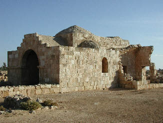
Qasr al-Hallabat is located just
off the main road about 30 kilometers east into the
desert from Zarqa. It was originally a Roman fort built
during the reign of Caracalla (198-217 CE) to defend
against raiding desert tribes. There is evidence that,
before Caracalla, Trajan had established a post there on
the remains of a Nabatean settlement. During the seventh
century CE, the site became a monastery, and the
Umayyads then fortified it and decorated it with ornate
frescoes and decorative carvings. Two kilometers past
Qasr al-Hallabat, heading east, are ruins of the main
bathing complex known as Hammam al-Sarah. The
baths were once adorned with marble and lavish mosaics.
Today, you can still see the channels that were used for
hot water and steam. |
Azraq Oasis

Azraq is located about 110 kilometers east of Amman at the
junction of roads leading northeast into Iraq and southeast into
Saudi Arabia. With 12 square kilometers of lush parklands, pools
and gardens, Azraq has the only water in all of the eastern
desert. The oasis is also home to a host of water buffalo and
other wildlife. There are four main springs which supply Azraq
with its water as well as its name, which in Arabic means
"blue." Over the past 15 years or so, the water level in Azraq’s
|
swamps has fallen dramatically due to large-scale pumping
to supply Amman and Irbid. This has resulted in the
destruction of a large part of the marshlands. While Azraq
remains one of the most important oases in the Middle East
for birds migrating between Africa and Europe, its
declining water levels have led many species to bypass
Azraq in favor of other stops. The area was once home to
numerous deer, bear, ibex, oryx, cheetah and gazelle, many
of which have been decimated in the last sixty years by
overzealous hunters.
Although the Iraqi border is far to the
east, the town of Azraq has the feel of a border town, as
there are no major settlements further east. There are a
number of cafés and small hotels, along with a Government
Rest House, in Azraq.
| |
Qasr al-Azraq
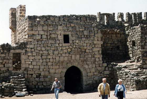
About 13 kilometers north of the
Azraq Junction, on the highway to Iraq, you will
find the large black fortress of Qasr al-Azraq. The
present form of the castle dates back to the
beginning of the 13th century CE. Crafted from local
black basalt rocks, the castle exploited Azraq’s
important strategic position and water sources.
The first fortress here is thought to
have been built by the Romans around 300 CE, during
the reign of Diocletian. The structure was also used
by the Byzantines and Umayyads. Qasr al-Azraq
underwent its final major stage of building in 1237
CE, when the Mamluks redesigned and fortified it. In
the 16th century the Ottoman Turks stationed a
garrison there, and Lawrence of Arabia made
the fortress his desert headquarters during the
winter of 1917, during the Great Arab Revolt against
the Ottoman Empire.
The castle is almost square, with
80-meter long walls encircling a central courtyard.
In the middle of the courtyard is a small mosque
that may be from Umayyad times, along with the main
well. At each corner of the outer wall, there is an
oblong tower. The primary entrance is a single
massive hinged slab of granite, which leads to a
vestibule where one can see carved into the pavement
the remains of a Roman board game. Above the
entrance area is the chamber that was used by
Lawrence during his stay in Qasr al-Azraq. The
caretaker of the castle has a collection of
photographs of Lawrence; in fact, his father was one
of the Arab officers who served with the legendary
Brit.
| |
Shomari Wildlife
Reserve

Situated about 15 minutes south
of Azraq, the Shomari Wildlife Reserve covers
22 square kilometers. The park is open daily
from about 07:30 until around 16:00. It can be
reached by following a desert road to the
western side of the reserve, which is
completely encircled by a fence. Numerous
species of wildlife, including ostrich,
gazelle, wild donkey, Arabian oryx and others
inhabit Shomari. While the park has been able
to protect these animals from being hunted,
the lack of water in this area has caused
these species’ habitat to shrink. Shomari’s
great success story is Operation Oryx.
This project has attracted worldwide
recognition for its reintroduction into the
wild of an almost extinct species, the Arabian
oryx. With its two straight horns and black
face markings, the white oryx once roamed the
deserts of Arabia and the Fertile Crescent.
Overhunting almost brought the species to
extinction, but because of careful management
Shomari now boasts around 200 Arabian oryx.
The reserve has also fostered 14 ostriches
from a single pair, and about 30 gazelles call
Shomari home, as well. For more information
about Shomari Wildlife Reserve, call the Royal
Society for the Conservation of Nature (tel.
533-7932).
Qusayr ‘Amra

Heading back towards Amman on
Highway 40, Qusayr ‘Amra is about 28
kilometers from Azraq. This is the best
preserved of the desert castles, and probably
the most charming. It was built during the
reign of the Caliph Walid I (705-715 CE) as a
luxurious bath house.
The building may have
been part of a larger complex that served to
host traveling caravans, which was in
existence before the Umayyads arrived on the
scene. The building consists of three long
halls with vaulted ceilings. Its plain
exterior belies the beauty within, where the
ceilings and walls are covered with colorful
frescoes. Directly opposite the main
doorway is a fresco of the caliph sitting on
his throne. On the south wall other frescoes
depict six other rulers of the day. Of these,
four have been identified—Roderick the
Visigoth, the Sassanian ruler Krisa, the Negus
of Abyssinia, and the Byzantine emperor. The
two others are thought to be the leaders of
China and the Turks. These frescoes either
imply that the present Umayyad caliph was
their equal, or it could simply be a pictorial
list of the enemies of Islam. Many other
frescoes in the main audience chamber offer
fantastic portrayals of humans and animals.
This is interesting in itself because after
the advent of Islam, any illustration of
living beings was prohibited.
Qasr al-Harraneh
This
well-preserved castle is located about
16 kilometers west of Qusayr ‘Amra and
55 kilometers east of Amman. The spot is
marked by an assortment of tall radio
pylons on the other side of the highway. |
| |
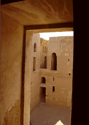 Qasr al-Harraneh
remains an enigma to archaeologists and
historians. Some experts believe that it
was a defensive fort, while others
maintain it was a caravanserais
for passing camel trains. Yet another
theory is that it served as a retreat
for Umayyad leaders to discuss affairs
of state. With its high walls, arrow
slits, four corner towers and square
shape of a Roman fortress, Qasr
al-Harraneh would appear to be a
defensive castle. However, the towers
are not large enough to have been an
effective defense, and may have instead
been built to buttress the walls. Qasr al-Harraneh
remains an enigma to archaeologists and
historians. Some experts believe that it
was a defensive fort, while others
maintain it was a caravanserais
for passing camel trains. Yet another
theory is that it served as a retreat
for Umayyad leaders to discuss affairs
of state. With its high walls, arrow
slits, four corner towers and square
shape of a Roman fortress, Qasr
al-Harraneh would appear to be a
defensive castle. However, the towers
are not large enough to have been an
effective defense, and may have instead
been built to buttress the walls. |
|
|
The arrow slits are also cosmetic, being
too narrow on the inside to allow
archers sufficient visibility and too
few in number for effective military
usage. We do know that an inscription in
a second-story room dates the
construction of Qasr al-Harraneh to 711
CE. The presence of Greek inscriptions
around the main entrance frame suggests
that the castle was built on the site of
a Roman or Byzantine building.
| |
Qasr
al-Mushatta

Just south
of Amman, Qasr al-Mushatta offers
an excellent example of
characteristic Umayyad
architecture. The castle is an
incomplete square palace with
elaborate decoration and vaulted
ceilings. The immense brick walls
of the complex stretch 144 meters
in each direction, and at least 23
round towers were nestled along
these walls. The palace mosque is
sited in the traditional position,
inside and to the right of the
main entrance. Throughout, there
is a powerful symmetry and
axiality in the planning, with a
tendency for compartmentalization,
often into three sections. The
vaulting systems are considered
essentially Iraqi, but the
stonemasonry and carved decoration
is Hellenistic. Both influences
are modified by their interaction,
and this palace presents the most
complete fusion of the two
traditions in Umayyad
architecture.
Historians
believe that Qasr al-Mushatta, the
largest and most lavish of all the
Umayyad castles, was begun by the
Caliph Walid II—who was
assassinated by forced laborers
angry over the lack of water in
the area. The palace was
constructed between 743-744 CE,
but was never fully completed.
Qasr
al-Mushatta is not on the Desert
Castle Loop. To get there, take
the Desert Highway south of Amman
to Queen Alia International
Airport. The castle is situated
right at the end of the north
runway. You must drive around the
perimeter of the airport to get
there. Turn right at the Alia
Gateway Hotel as you approach the
airport and the road will take you
past two checkpoints and on to the
castle.
Qastal
Qastal is one of the oldest of the
Umayyad palaces, as well as one of
the best preserved. The remains at
Qastal include a wide variety of
sites such as the central palace,
baths, a reservoir, a mosque,
small houses, a cemetery—the
oldest Muslim graveyard in
Jordan—and a dam. The central
palace was decorated with stone
carvings, and twelve semi-circular
turrets buttressed and guarded the
walls. The courtyard of the palace
housed a central water tank. North
of the central palace are the
remains of the mosque.
Interestingly, it is not oriented
precisely eastwards facing Mecca.
One kilometer east of the main
complex are the remains of a stone
dam, constructed to retain
rainwater. Formed from the quarry
which supplied stone for Qastal’s
palace, the dam had a capacity of
around two million cubic meters.
Qastal was probably built in the
early Islamic era by the Umayyad
Caliph ‘Abd al-Malik ibn Marwan,
who is known primarily for
building the magnificent
Dome of
the Rock
Mosque in Jerusalem.
The palace
of Qastal is very easy to find,
100 meters west of the Desert
Highway near the town of Qastal,
25 kilometers south of Amman. |
|
|
|
|
|
 |
|
|
|
|
|
|